Restricting vehicle access along La Rambla
Thematic areas
Demand & urban space management
- Access restrictions and management
- Road pricing
- Parking management and pricing
Summary
Camera-based access control was introduced along a section of La Rambla, the 1.2-kilometre-long pedestrian street in central Barcelona, using automatic number plate recognition (ANPR) technology.
Implementing sustainable mobility
Around 10,000 vehicles per day use La Rambla to travel from Passeig de Colom to Placa de Catalunya. This traffic includes significant numbers of public service and goods delivery vehicles. Whilst the service vehicle traffic is too great for the municipality to consider a full, immediate pedestrianisation of the street, the number is small in comparison with the volume of pedestrians, which can exceed 7,000 people per hour.
Surveys undertaken by the municipality indicate that a significant part of the flow of vehicles is through traffic, and that most of these vehicles pass at times when there is a high level of pedestrian activity. There are many accidents involving pedestrians along La Rambla.
The proposal was to restrict vehicle access to authorised classes of vehicles (buses, taxis, residents and special service vehicles) and to maintain open access for vehicles using any of the three off-street car parks located along La Rambla. The restrictions are in place between 11.00 and 20.00, in order to reduce traffic flow when the volume of pedestrians is greatest. In order to maximise pedestrian safety, speed limits of 30km/hour were introduced.
Progress
ANPR technology is used to identify vehicles passing along La Rambla. Recorded images of vehicles recognised as authorised (i.e. on the “white list”) are deleted and no action is taken.
Recorded images of vehicles travelling at more than 30 km/hour, as well as vehicles not featuring on the “white list” and those not using one of the designated car parks, are archived for use as evidence and fines are imposed on the vehicle owners.
The automated system can be used by the police to identify habitual offenders, and police can also use the system to spot vehicles without legal number plates. The restrictions apply equally to two-wheeled motorised vehicles in order to reduce noise pollution and maximise pedestrians’ safety. The fact that two-wheeled vehicles only have rear-mounted number plates determines the location of the roadside cameras. Both cable-based and mobile telephone technologies were explored in order to ensure the high-capacity, secure transfer of data between the roadside cameras and the municipality’s traffic control centre. In the first phase of implementation, the controls at the beginning and end of La Rambla were installed using fibre-optic links.
Outcomes
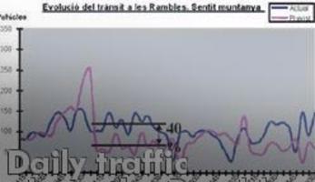
The scheme is reducing traffic volumes during the controlled hours by 40 percent, which represents a considerable improvement in pedestrian comfort and safety. Overall daily traffic has been reduced by between 10 and 15 percent, with higher levels of traffic prior to the start of the access control period at 11.00 hours.
This fact sheet has been updated by a third party on the basis of available information (not by the city itself). We are therefore unable to guarantee that the data provided are complete and up to date.


